Hurricane Isabel, 2003 September
17-19: the Windy One
Hurricane Isabel was the most memorable and the worst weather
event in my life. I saw some really fast winds for the first time, including
whole gale or 63 mph winds, and a record number of power outages. Further,
the Outer Banks' geography appearently was changed.
In my blog, Blogtrek, I made eight
reports on Isabel and one on Fabian, which I also thought might hit here.
I saw this storm as early as 2003 September 8 on the Global Forecasting System
(GFS). On this page I have placed all of these blogs; it makes for an interesting
history of this storm.
Chronology of Isabel
-
- Isabel and the GFS
- Isabel Day 2: Deep Impact
- Isabel Report 3: Consistency Developing
- Where is it headed? Isabel Report 4
- Isabel Looks Like Gloria: Report 5
- Isabel Report 6: National Guard Shortage
- Report 7: Isabel Surprises
- Isabel: The Windy Storm
(after the storm)
Hurricane Coming?
I heard on the news recently that a tropical wave way out in the Atlantic has
become Tropical Storm Fabian, and just tonight it became Hurricane Fabian. It
is way out to sea but I want to see if it would affect where I am living (in
central Virginia). So I checked the hurricane sites such as Weather
Underground's site. It shows the future track of the tropical storm for
a few days and shows that it will skirt north of the Caribbean islands, such
as the Leeward Islands. But that's not far enough. I want to know if it will
hit the mainland United States, and if so, where. There are two sources of this.
I tried the Global
Forecasting System first. I checked it two days ago and it said that Fabian,
which I suppose will become a major hurricane, will hit Miami, then go in the
Gulf and hit Fort Walton Beach, Florida, then go off to the northwest and peter
out and not affect central Virginia. I checked it again today. The forecast
has changed. The 384-hour
forecast shows that Fabian will approach Florida, turn up to the north,
strike the Wilmington, NC area and make a direct hit on central Virginia. We
hardly need this here in Virginia. We have had enough rain this year, and a
6-10 inch deluge, which is what this storm would produce, would cause massive
flooding all over the place. I also checked Gary
Gray's discussion and he says it may come up the Eastern seaboard, saying
that the GFS scenario has Fabian first "taunting Florida" then "slamming hard
into the Carolinas". But he notes that there are other models that take it out
to sea, and still others that cause it to go poof midsea, sort of like Debby
did near Hispaniola in 2001.
I will be monitoring this storm carefully. The local news media don't mention
it much at all, and it could conceivably go another way. But it seems like it
is going to become another Fran or Floyd. Watch out for those F storms, those
storms that have an f-word for their name, such as Fabian. By the way, these
links are likely going to become different or invalid in a few days.
posted by Jim on 8/29/2003 04:47:02
PM
Isabel
and the GFS [Report 1]
It's late summer and early autumn, so it's hurricane time. And sure enough,
there are two hurricanes and two tropical depressions out there. Hurricanes
are rather unpredictable creatures. For example, take Fabian. It looked like
it was going to curve to the north and go out to sea, and so not harm any land
areas. Well that it did, but it unexpectedly gave Bermuda a direct hit, and
now they are cleaning up the mess there. It's gone but there is another storm
out there, Isabel. It is following the path of Fabian. So where is Izzy going?
It is way to the east of the Leeward islands, and so it will take several days
even to get there. After then, will it go out to sea or will it hit the US or
somewhere else? This is way off in the future and so a weather prediction or
model system is needed that will go out as far as possible. NOAA's Global
Forecasting System or GFS goes out to a whopping 16 days! That is time
enough to find out what happens to Isabel. For a while GFS was saying that it
was going to go out to sea. Then Gary
Gray pointed out that the 2003 September 7 12Z (Z means Greenwich Mean time
or Universal time) run of GFS shows Isabel slamming into New England, creating
a new version of the Great New England Hurricane of 1938. This would happen
about two weeks from now, around September 21. Gary Gray points out that he
has no confidence in this forecast, because it is so way out in the future.
Indeed, future runs show other things. The 2003 September 7 18Z run shows Isabel
once again going out to sea, and the 2003 September 8 0Z run shows it slamming
into Nova Scotia and Newfoundland. The 6Z run today says it will go to Ft Lauderdale,
Florida, then head into Tennessee, join up with an ordinary low, and create
the biggest floods this country has seen since Agnes in 1972. The 12Z run shows
it hitting midway between Massachusetts and Maine, and the latest run, 18Z,
is even more horrendous. First it heads into the Delmarva Peninsula, right into
Baltimore's inner harbor. Then it goes up the Delaware River, into Pennsylvania
and New Jersey, giving New York City a big whack. Then it curves into New England.
If this happens it will be the most destructive hurricane in history, because
this area is heavily populated with a lot of development.
The point here is that the forecast is all over the place. It could hit Florida,
it could hit Virginia, it could hit New England or Nova Scotia, it could go
out to sea or even hit Bermuda again. That is why we don't see this on the TV
weather report. The TV weatherman's job is to predict, and watching a model
go from here to there as newer editions go out is not predicting, which requires
saying definitely where it will go.
But nevertheless it is interesting to watch the forecasts. In a sense there
is a virtual storm out there, hanging in the future, hitting all these places
as time goes by, and as the storm gets closer, its variations will damp out
and become more consistent. Then we will know where the real storm will hit.
Further, you can get some idea of where it will hit from these forecasts. The
runs seem to center around the New England and New York City area, so I think
this area is the most likely to get hit. Further, it is not coming in at a usual
angle in any of these runs, except those that take it to sea. It looks like
it goes out to sea, then it bends to the west or northwest. This makes striking
Delmarva, New Jersey, or New York more likely than usual. This is therefore
a storm to watch. By the end of the week, we may know just who Isabel is going
to visit.
posted by Jim on 9/8/2003 07:58:45
PM
Isabel
Day 2: Deep Impact
Isabel is continuing to head north of west. Forecasters have been saying she
should head due west, but so far it has not happened. She has reached 20 degrees
north, and according to these forecasters, she should now turn west. We will
see if she does so.
In the meantime, I have four more Isabel scenarios from GFS. The latest one
takes it right into central Virginia, where it piles more rain than we ever
need this year. Here is the Isabel summary, where the 0, 6, 12 and 18 are the
hours of the runs in Universal Time:
2003 September 7
12 - New England
18 - sea
2003 September 8
0 - Maine
6 - S. Florida
12 - Nova Scotia
18 - Delmarva, Baltimore 2003 Sept 21 2 am EDT
2003 September 9
0 - sea, turning around on 2003 Sept 23 8 pm EDT
6 - Nova Scotia 2003 Sept 23 2 am EDT
12 - Myrtle Beach (another Floyd) 2003 Sept 23 8 pm EDT
18 - S. Florida, then heads up to Central Virginia 2003 September 23
That's the date it strikes Florida. It strikes Virginia a day later, and then
heads towards New York City. This pattern of hitting some place on the East
Coast has now come with about 75% of the runs. As Gary Gray says, "It remains
way too early to say anything solid on that. Suffice it to say that the model
trends and unanimity favor some sort of impact." You heard it folks. Deep Impact
is coming. It's two weeks away. Where it will strike is anybody's guess - might
as well play roulette. But it's likely to impact somewhere, so the entire East
Coast should monitor this storm.
posted by Jim on 9/9/2003 08:23:51
PM
Isabel
Report 3: Consistency Developing
Here are the runs since yesterday of GFS, showing where Isabel strikes:
0Z - Charleston, SC
6Z - hanging off the coast of central/southern Florida for 4 days, then head
to Charleston, SC
12Z - grazes east coast of Florida, then hits NC and gets into Central Virginia,
in one day
18Z - hits Miami, then turns north, scrapes the entire Florida coast, goes off
the coast along the Carolinas and Virginia, giving them a deluge.
There is some agreement in these runs now. They aren't popping all over the
place, Florida one hour, Nova Scotia the next, sea after that, and so forth.
They are settling down on a path towards Florida, then coming up the Southeastern
seaboard. So it seems that this is where Isabel is headed. The manner is still
undecided; one run hangs it around Miami for 4 days, the others move it quickly.
But they agree on Florida, Carolinas, and Virginia, and this is the area that
needs to watch the most for Isabel. These areas need to keep abreast of the
storm.
Further, I notice another storm coming. Unless some mess somewhere develops
a wind and circulation, this will be called Juan. It is forming off the coast
of Africa right now and will follow the path of Fabian and Isabel. However,
it looks like this one will turn out to sea.
2003 September 10 2124. I just got Gary
Gray's analysis. He is making a prediction. Yes, this is 10-12 days out,
yet he is making a prediction. He agrees with me that the model runs are showing
consistency from run to run and among the rather sparse set of models as well.
He says the hurricane will move just north of the Bahamas, turn north, then
northeast, then hit the Carolinas. He does not say that Florida will be hit,
whereas I say it above. He mentions that the GFS has a solution that almost
takes it into the Gulf of Mexico before a ridge catches it, pulls it up the
Florida coast, then skirts it by the Carolinas. But other models call for it
to be farther east, missing Florida. Apparently Isabel is headed our way; it's
going to be like Floyd in 1999. I still say interests in Florida and the Carolinas
should watch this storm carefully.
posted by Jim on 9/10/2003 04:58:52
PM
Where
is it headed? Isabel report 4
This morning I got a jolt. For the past day or so, the GFS runs have been indicating
that it would go by peninsular Florida, then head out to the northeast and hit
the Carolinas, and Gary Gray came to that conclusion also. I looked at the GFS
run this morning and found to my surprise that it was going to go to New Jersey
instead! That would have meant hurricane force winds in New York City. The 12Z
run took it to eastern Nova Scotia, and 18Z has it pounding the Canadian Maritimes
and causing a major disaster there. So now what? Where is this thing going?
It is starting to go east and pop all over the place again.
Tonight I took a look at Gary Gray's take on the storm. He says that the GFS
tends to let go of ridges and troughs too soon, and in Isabel's case that would
take it farther to the east. The maps indicate a huge high in the north Atlantic
that blocks Isabel and makes it go west. He concentrated on other models, including
one called ECMWF. So I took a look at that myself. It only goes 6 days and at
that time, next Wednesday, it has it out in the middle of the Atlantic, but
in a trajectory that would take it to New England. So it sort of agrees with
GFS. Gary Gray winds up concluding that it is likely to hit either the Carolinas
or New England. So both areas need to watch for this storm.
The other thing I notice about it is Wow!! It is up to 160 mph, making it a
Category 5 hurricane. This has me concerned. Sustained 160 mph winds would really
cause damage to an area. Even 140 mph winds would, if it should weaken a bit
before hitting shore. So that has me concerned about hurricane force (75 mph)
winds in my area, which would knock trees down everywhere and cause some roof
damage. But it is not the most forceful tropical storm out there now. Typhoon
Maemi had 175 mph winds gusting to 205 mph and is forecast to turn northeast
and go between Korea and Japan; it is now down to 140 mph.
posted by Jim on 9/11/2003 09:35:16
PM
Isabel
looks like Gloria: Report 5
Here are the past few runs' results:
September 12
0Z - Delmarva Peninsula
6Z - Skirting Delmarva, enter at New Jersey
12Z - Delmarva Peninsula, then towards Buffalo, NY
18Z - Delmarva, VA, then towards Buffalo, NY
September 13
0Z - New England
6Z - New Jersey and Long Island
Yesterday the runs were all alike, and they corresponded with other runs too.
They imply a landfall somewhere in Eastern Virginia, which had me concerned.
Isabel was going to come in at an unusual angle, headed northwest. Then this
morning's runs come in saying that it is going to miss Virginia altogether and
head to New England, and at 6Z, it came a little closer, heading to Long Island.
The other models don't seem to go out far enough, and they are hard to find
on the Internet. But I did find GEM, which is a Canadian model, and that one
looked really interesting. Isabel would head to Norfolk, skim by Norfolk and
Baltimore about 150 miles off shore, then make like it was going out to sea.
Then it makes a subtle turn to the Northwest and scores a bulls-eye on New York
City, on downtown Manhattan. Considering what happened two years ago, I think
New York will be well prepared for this storm if that happens.
But where will it actually go? There is still some variance in the models. I
looked at past history and found that Isabel is different from Fran, different
from Hugo, different from Floyd. Hugo really concerned me. It hit Charlotte,
NC with 85 mph winds, causing power outages to 95% of the city and covering
some streets with downed trees, and this is as far inland as Richmond is.
I got a clue this morning from the track. It looks a lot like Gloria in 1985.
The path is similar, going north of the Caribbean islands and then heading for
the Outer Banks. Like Isabel, Gloria had high winds, up to 150 mph, and a really
low pressure besides. As Gloria approached, the winds died down, as Isabel appears
to be doing now. Further there was a weak tropical storm named Henri (this was
18 years ago and hurricanes repeat names every 6 years, and 6 divides 18 evenly)
just like now that went up the coast before the big storm arrives. Like now,
there was a front going across the mid part of the nation, from Wisconsin to
eastern Texas.
So to determine where Isabel is going, look at how it differs from Gloria. Gloria's
Henri, for instance, developed out of nowhere off South Carolina and then went
up the coast in a straight line. 2003's Henri developed in the Gulf of Mexico
instead, crossed Florida and petered apart a while in the Atlantic before moving
west to hit the coast, then move northward. This does not tell much about where
Isabel is going, but we need to look at differences between the storms to give
us a clue.
posted by Jim on 9/13/2003 08:18:41
AM
Isabel
Report 6: National Guard Shortage
I have seen all of the runs of GFS today and they all say pretty much the same
thing: Isabel is going to just miss the Outer Banks, come ashore somewhere around
Norfolk, ride up the Chesapeake to Baltimore, then head straight for Rochester,
NY. The population potentially affected by hurricane force winds is huge: Washington,
DC, Baltimore, Philadelphia, maybe even New York, and then the upstate New York
State cities, especially Rochester.
It is apparently not losing its maximum wind speed much, now about 155 mph.
The weather forecast seems to say it will be 120 mph at landfall - a Category
3 hurricane. I am not sure what this will mean to places on the periphery of
its clouds; I can't find the maps that show predicted wind speeds out to whichever
radius. But they are powerful. If they hit the Outer Banks that powerful, it
may redraw the geography. It may destroy the Oregon Inlet Bridge, but it may
also fill in the inlet, meaning that they would simply pave an at-ground road
instead of building a bridge. But another inlet will open up elsewhere, requiring
the bridge there, perhaps somewhere on Pea or Hatteras island. That was open
before at Pea Island and there is an abandoned bridge there which crossed that
inlet.
After the hurricane, rebuilding will need to take place, and usually the National
Guard is called out to help. But when we call on the National Guard this time,
there may be no Guard we can call on, or inadequate Guard, because these troops
are all in Iraq. They may have to borrow from Guards in other states, even though
they are short too. It seems to me that we didn't need to pile all those troops
in Iraq - they are needed in the states at times.
posted by Jim on 9/14/2003 07:43:30
PM
Report
7: Isabel surprises
Just as it seems the models are in agreement and Isabel is headed right up the
Chesapeake Bay straight towards the Washington Monument with 120 mph winds,
Isabel pulls some surprises. They were talking about some shear affecting her
progress. Today she got clobbered by it and her winds, despite an incredible
tornado-like 236 mph gust in the clouds, dropped from 145 mph to 125 mph. Her
huge eye, as if it suddenly looked into the bright sun, shrunk and shrunk until
it vanished. She is predicted to hit another shear tomorrow and become even
weaker, but she may grow stronger over the warm Atlantic, but then she may get
weaker in coastal waters. It's a "good news, bad news" game. And now she has
pulled another surprise tonight. The GFS, ETA, and all of the "SHIPS" runs now
show Isabel hitting further south in North Carolina, like at Morehead City,
then heading northwestward into western Virginia, Tennessee, and West Virginia.
The Canadian GEM still shows her shooting up the Chesapeake but not as severe
as before.
So what does it mean? Maybe Washington, Baltimore, and especially Hampton Roads
are off the hook. It would be headed straight for Richmond, but go south of
there and because of crossing over all that land, it weakens to tropical storm
force with some hurricane winds over water. There would be no major catastrophic
storm; as Gary Gray says, the Atlantic Coast won't fall off into the sea.
But keep alert, because more surprises may be coming. She may head to New England.
She may hit South Carolina and produce floods there. She may even get into western
Virginia, wheel around, and head back to Philadelphia and New York. Hurricanes
are notoriously unpredictable and we should keep alert. Gov Warner was right
in calling a state of emergency in Virginia. Hope he can deal with this emergency
without the National Guard troops that can't help because they are in Iraq.
posted by Jim on 9/15/2003 07:11:59
PM
Isabel the Windy Storm
This is my last report
on Isabel. It was hard to see from radar just where this storm was going. Its
wobble first had it seemingly scraping the coast, then at another time, it seemed
to be headed straight to Raleigh. But it followed pretty much what the models
and NOAA had been saying about what the storm would do. Floyd in 1999 was a
rainy and floody storm. Isabel was a windy storm - not too much rain fell.
I was afraid of the high winds that would come here. They were predicting 75
mph winds for Petersburg. They canceled my place of work for two days, so I
was at home when it occurred. In the morning it was a gentle but steady breeze.
It started to increase by lunchtime. It seemed like it was almost calm at ground
level - our maple tree did not sway much, but the tall trees, about six stories
high, swayed back and forth. In the afternoon, the wind got much fiercer, blowing
twigs off the trees, but then it eased up about 3 pm to 5 pm. They started picking
up after 5 pm, and we lost power at 1729 (5:29 pm). At that time the center
of the storm was just crossing into Virginia. I did not get any more visual
pictures after that; the TV station was broadcasting over radio, and I could
hear what the weatherman was saying. At 1852 a roar occurred outside. When it
arrived, the trees in our back yard started bowing way to the left at a 45 degree
angle or more, and one tree bowed over straight. It was falling down! It landed
harmlessly along our back yard boundary, although it missed our telephone box
by about two feet. The storm continued from 7 pm to 10 pm, howling and producing
more wild bendings of the tree. I heard that the TV station recorded a gust
of 63 mph - on the boundary between whole gale force and storm force - now I
know what a whole gale is like. Sure enough, it uproots trees. After 10 pm the
winds died down considerably, and the rain ebbed to a mere drizzle. Hardly any
rain, but the wind was still fast and howling. I went to bed and heard them
and it seemed soothing in a way, like there was something going on out there
and I was safe in bed - it was the same sort of feeling as when I get when I
hear a train pass about two miles way.
The next morning, I went out at 7 pm. Guess what? There was a party going on
in the street. The weather was beautiful. There was lots of clear sky and some
altostratus clouds, and it was nice and cool. We went out in the neighborhood
to see the damage. I found out that a tree had fallen on another tree near our
house. On one corner of our house, about 10 feet away, there are three trees
and I was afraid that a storm some day would blow them on our house and cause
serious damage. So I wanted to get rid of them, but an association board member
and a tree surgeon told me that they were sturdy trees - the house would go
before them. So I never got around to having them chopped down. Good thing I
didn't. One of those trees protected my house from being hit from the tree behind
it in my neighbor's yard. If I had had those trees removed, the tree from the
neighbor's yard would have damaged my house. I will probably leave them there,
then; they are guardian angel trees. The neighborhood had lots of trees down,
including an attractive willow. Two houses were damaged by a tree hitting a
corner of their house.
Phone service went out with the power, and I figured I would have to wait a
day or two for power. But surprise. It came on at 1519 yesterday (2003 September
19), and so did the phone service, but not cable TV. But still I seem to be
in a favored class. 325,000 out of 425,000 customers of Virginia Power currently
don�t have power. So cable TV (and high-speed Internet) seem to be small potatoes.
It does indeed affect me still. The gasoline stations are closed because of
lack of power, and those that are open have huge lines at them. This suggests
what will happen when the Big Petroleum Shortage Rollover occurs, probably near
the end of the decade, from what some geologists say. The banks are closed,
and I am afraid to use ATMs for fear they will swallow my card. It was to be
an active weekend, but Isabel wiped out four, or possibly six, events that I
was maybe going to.
It was the worst storm ever to have hit the area that I lived in. It was worse
than Fran and Floyd. Fran gave us a 2.5 hour power outage, and we never lost
power during Floyd. The only storm that comes close was the Great Christmas
Eve Ice Storm of 1998, which caused a 21-hour power outage at my house. The
unusual thing about it is that 16 days before, on 2003 September 8 (it looked
like it would hit on the 24th then) I knew that it could hit the East Coast.
At that time I saw a virtual storm coming. Well, the virtual storm headed straight
towards the real storm and came together right over my head.
Look at my weather
page. I had not changed this in a while, but I am going to be converting this
to a page on Isabel, including all the blogs that I have made to Blogtrek on
this hurricane.
posted by Jim on 9/21/2003 09:42:45
AM
Predictable/Unpredictable
With situations of the kind that hurricanes posed, it seems that things are
either in fine agreement or they are haywire all over the place. There is no
middle ground. With Isabel, the first few runs were all over the place: sea,
Florida, Baltimore, New England, Nova Scotia. But then after a few days they
consistently pointed a finger at North Carolina and Virginia. There was no mildly
unpredictable phase. It is either precise enough to predict accurately or you
can say absolutely nothing about it.
Similar situations happen in mathematical systems. For example, in estimating
a quantity, such as the length of the tropical year in solar days, 365.2422,
the first three decimals are just about absolutely accurate. The fourth one
is about right, the 2, but it is fuzzy and I have heard estimates that begin
with 365.2421. After that the digits are totally unpredictable and depend on
the irregular rotation of the earth. Another example would be to observe that
if x is the square root of 2, then x = 1 + 1/(1+x) so if one guesses a value
for x, substitute it into 1 + 1/(1+x) and make that your revised value of x,
one may hope to obtain sqrt(2). If you set x = sqrt(2) you get sqrt(2) back,
but if you are off by a little bit, say x = 1.414213562373, then the next few
approximations are about this value but they lose a decimal place of accuracy
each iteration. Still, it is good enough for practical purposes. When this gets
back to the units digits, the whole thing becomes unpredictable. Try it out
on a spreadsheet and you see what I mean.
Why does this happen? Both the hurricane and the iteration formula are unstable
equilibria. If you are right on the money, you remain so, but if you are not,
you eventually get thrown off the track. And that is what happened to the first
few predictions for Isabel, 12 days ago.
posted by Jim on 9/15/2003 07:11:17
PM
Isabel
and Dark Skies
Isabel caused a lot of power outages, damage to homes caused by trees, and
other destruction. But when it left, it left behind a jewel. I went outside
yesterday (2003 September 19) to see the stars, and I saw the darkest, most
brilliantly star-studded sky that I have ever seen from my house. About 80-90%
of the surrounding area did not have power. Therefore, the sky glow from light
pollution was a lot less. I could easily see all the stars of the Little Dipper,
and the Milky Way was visible from horizon to horizon. I went out with my
telescope to try to see Mars, but I had trouble aligning my telescope, and
I think part of it was that it was running on batteries. I did see it eventually
and saw a dark stripe across the middle of the Red Planet. It was a real treat
seeing a sky so dark from my house and I realize that this is something that
occurs only about once every 50 years, when a hurricane as powerful as Isabel
comes through here. I know that a teen-age woman named Jennifer
Barlow has been trying to get people to turn off their outside lights
in order to provide for a dark sky; in particular, declaring a Lights Out
day. That was not too successful. It seems that Jennifer couldn't get people
to turn off their lights. But Isabel could, and did. What is this society
we belong to coming to anyway, when we need a hurricane to be able to see
the night sky? I say make every day a Hurricane Isabel day. If you
could not turn on an outside light during Isabel, then don't turn it on at
all. I know some lights are needed for safety, but these may be far
fewer than most people think. If everyone would do this, dark skies and knowledge
about astronomy, especially among young people, would return.
posted by Jim on 9/21/2003 09:43:44
AM
Isabel
and nautiluses
On 2003 September 17, Hurricane Isabel changed from its normal spiral galaxy-like
shape to a spiral shape reminding me of a nautilus. It was interesting how
the 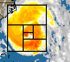 storm looked on radar when it was about 24
hours from landfall. The hurricane looked like a smaller copy of itself with
a spiral tail coming from it. This means that the smaller copy looked like
an even smaller copy of itself with a tail coming from it. A nautilus has
a similar structure, and it is remarked that the ratio of the size of the
nautilus to the smaller copy of itself is 1.618033989 or (sqrt(5)+1)/2, the
golden ratio. However, Isabel's spiral did not fit that description. I used
Paint Shop Pro to make an estimate of the sizes of the smaller copy of Isabel
and its tail, and found the ratio to be somewhere between 1.29 and 1.35. This
means that the tail is not in a square box, like it is for the nautilus. It
is more of a rectangle, and one can build spirals with any kind of a winding
ratio. I wonder if this ratio of about 1.32 is common among hurricanes or
if anyone has studied it. I tried to estimate the rotation speed. I got first
of all about one rotation every 12 hours and then a little while later, it
was one every 6 hours. I tried to make a prediction of intensity levels based
on this - it would get strong on Thursday afternoon, then weak later in the
afternoon, then really strong at night in two separate bands. I was pretty
much correct - I observed these things actually happening.
storm looked on radar when it was about 24
hours from landfall. The hurricane looked like a smaller copy of itself with
a spiral tail coming from it. This means that the smaller copy looked like
an even smaller copy of itself with a tail coming from it. A nautilus has
a similar structure, and it is remarked that the ratio of the size of the
nautilus to the smaller copy of itself is 1.618033989 or (sqrt(5)+1)/2, the
golden ratio. However, Isabel's spiral did not fit that description. I used
Paint Shop Pro to make an estimate of the sizes of the smaller copy of Isabel
and its tail, and found the ratio to be somewhere between 1.29 and 1.35. This
means that the tail is not in a square box, like it is for the nautilus. It
is more of a rectangle, and one can build spirals with any kind of a winding
ratio. I wonder if this ratio of about 1.32 is common among hurricanes or
if anyone has studied it. I tried to estimate the rotation speed. I got first
of all about one rotation every 12 hours and then a little while later, it
was one every 6 hours. I tried to make a prediction of intensity levels based
on this - it would get strong on Thursday afternoon, then weak later in the
afternoon, then really strong at night in two separate bands. I was pretty
much correct - I observed these things actually happening.
What caused the nautilus structure? I think that all spirals, including spiral
galaxies and hurricanes, have this type of structure, although it may look
like a disk. Most hurricanes and unbarred spiral galaxies have several spiral
arms that make it look like a solid disk. Isabel caught a collection of cold,
dry air in its western periphery, and this cold air got into it destroying
some spiral arms. Only one was left, and this enables one to see the spiral
structure easily. It looked like Isabel had several eyes at one point. In
any case, it did not affect the predicted (which turned out to be actual)
effects of Isabel, as one of the worst hurricanes of our lives.
posted by Jim on 9/21/2003 09:41:16
AM
Other
weather links
The following is my original weather page. I have revised the links to include
the ones that have been most helpful to me in tracking the weather, including
Hurricane Isabel.
1999 Averages, Stoney Glen
Development, Chester, VA
This says that we get a lot of rain in September but this is only one year's
data - a year that included Hurricanes Floyd and Fran.
| |
Avg High |
Max |
AvgLow |
Min |
Prec |
Sun% |
| January |
54.6 |
78 |
29.9 |
10 |
5.25 |
61 |
| February |
55.4 |
74 |
30 |
14 |
1.45 |
58 |
| March |
57.8 |
83 |
33 |
21 |
2.71 |
56 |
| April |
70.5 |
89 |
43.7 |
31 |
1.59 |
65 |
| May |
76.4 |
87 |
55 |
39 |
2.41 |
65 |
| June |
80.4 |
95 |
61.6 |
45 |
3.3 |
42 |
| July |
87.4 |
98 |
70 |
58 |
3.74 |
55 |
| August |
86.4 |
97 |
68.8 |
63 |
4.44 |
54 |
| September |
76.3 |
86 |
60.3 |
43 |
18.77 |
43 |
| October |
67.5 |
79 |
46.3 |
33 |
2.78 |
69 |
| November |
65.6 |
80 |
41.2 |
15 |
1.27 |
74 |
| December |
54.1 |
74 |
31 |
23 |
1.94 |
65 |
| 1999 |
69.4 |
98 |
47.6 |
10 |
49.65 |
61 |
|
Weather Links
General Weather Sites
- Weather Underground
at www.weatherunderground.com/us/va.
For another state, substitute the state's two-letter
abbreviation for "VA" This site is my favorite for finding the current
weather. The site is usually quick to come up, and it gives all the essential
details for each site, including the official NOAA forecast for sites in the
USA, There are lots of popup ads, you can suppress them either by using a
popup suppression program or by paying a $5 per year fee.
- Weather.Com This is the Weather Channel's
weather page. It features many maps and forecasts out to 10 days together
with averages in a colorful setting. Some of the popup ads that appear on
this site prevent you from using it; a serious disadvantage at times. The
site also features hour by hour weather for 2 days, which is not always accurate.
- Accuweather. Accuweather also features
many maps and a colorful setting. The forecasts go out to 15 days; there is
reason to suspect the accuracy after day 7; read my descriptions of Hurricane
Isabel above for more information on this. Sometimes the information comes
out inaccurate; for example, not calling for a big pile of rain and wind on
the day that Isabel came. There are ads on this site but not as intrusive
as with Weather.com.
Note: I have discontinued the
warning I had issued for Weather Underground for its opening up CD-ROM drives
without warning, because I have not observed this phenomenon in a while. So
Weather Underground is OK to use now. Continue to be cautious about CD-ROMs
suddenly opening up when visiting web sites.
Radar:
- Virginia Doppler Radar Radar
on local Richmond station WWBT-TV.
- Doppler
Max 6. Radar on local Richmond station WTVR-TV.
- National
Radar Image from Intellicast. Large file; slow to load at times but gives
excellent picture. It also features radar loops, which give you a "movie"
of the radar blips, at one frame an hour for two hours.
Winter Weather
- Canada's
Temperatures. This site by Weather Underground provides a temperature
map of Canada that describes temperatures as low as 60 degrees below zero.
In the winter, this shows where the cold areas are and so can give you advance
warning several days ahead of cold weather and snow in your area.
- Millennium Weather
Gives you NOAA's predicted track for winter storms as well as the predicted
tracks given by several mathematical models. The best part is the discussion
by Gary Gray, who gives detailed analyses of winter storms as the come by.
He does tend to be long winded at times and repetitive but there is nothing
I have seen that matches this site for interpretation of the models and of
weather data coming in.
Hurricanes:
- Terrapin Excellent site to
find the latest track of that hurricane. Also gives you a movie of a hurricane
symbol going across a map if you have Java.
- Millennium Weather
Gives you National Hurricane Center predicted track as well as the predicted
tracks given by several mathematical models. Links take you to the Millennium
Weather page, which has model discussions, graphics, and lots of hurricane
links. The best part of this site is the discussion by Gary Gray, who gives
detailed analyses of hurricanes as they prowl the Atlantic, Gulf of Mexico,
and the Carribean. He does tend to be long winded at times and repetitive
but there is nothing I have seen that matches this site for interpretation
of the models and of weather data coming in.
- Weather Underground
Weather Underground has an excellent weather page in everything else, and
so they have a excellent hurricane page, too. This site shows visible and
infrared pictures of hurricanes and forecasted tracks. One of the more fascinating
displays this site has is map showing the tracks of all storms from around
1890 to the present time that came close to where the hurricane is now. Hurricanes
have a habit of pulling off surprises that have never happened before, so
this gives only a general idea. For example, when Isabel was 24 hours from
the coast, a display of past hurricanes going through where Isabel was shows
<i>all</i> of them heading out to sea. That is not what happened!
But the site still gives a general idea. Some of the animated images require
a payment.
Weather Models
These are computer models run to determine what is going to happen to weather
systems over the next 2-16 days. They are used by meteorologists to determine
the forecast you see on TV, radio, newspapers, and sites such as weather.com.
The raw model results are also available on the Web, so you can bypass these
garbling middlepeople and go straight to the source. These includes such models
as GFS (16 days), NOGAPS, ETA, GEM, ECMWF (European), and UKMET. However, you
have to know how to interpret the maps; for example, to know that an L with
a bunch of colored rain bands around it is a predicted hurricane or not. I have
not fully understood them enough but enough so that I could make the predictions
above, with a little help from Gary Gray. Use them but remember that things
may not be as they seem on these model outputs.
- National Centers
for Environmental Prediction (NCEP). This is the best site for getting
model predictions. It gives GFS in full detail, with about 12 types of maps
for each of 12 or 24 hours out to 16 days - an enormous amount of information.
It also gives ETA and NGM model results.
- Unisys This site is good for some
results - note that it calls GFS by the names AVN and MRF, the predecessors
of GFS. MRF goes out only to 10 days, so this site does not give all the results
of NCEP. But it gives a number of other model results that NCEP doesn't, for
example, ECMWF.
- Millennium Weather The winter
storms part of this site has a list of sources for the major models. I don't
know why it comes under winter storm discussion, because the models are an
essential part of hurricane prediction too. But it is a comprehensive list.
Last modified 2003 September 21. Picture on main page square is that of Hurricane
Floyd in 1999 - NOT Hurricane Isabel.
Back to Main Page